Everything You Need to Know for Travel To/From the Viking Terminal – Slussen and Stockholm City
To/from the Viking Line terminal (Stadsgårdsterminalen) on Södermalm, Stockholm.
If your legs are tired, a bus ride to/from the Londonviadukten stop can help. But walking is just as feasible—it takes 20–30 minutes.
- Either along the Stadsgårdskajen.
- Or a slightly faster route via Folkungagatan to the subway stations Medborgarplatsen or Slussen.
- Or why not take a more scenic walk, for example via Söder’s heights and the Katarina Elevator.
Click for OpenStreetMap
Viking Line Directions.
GPS System WGS 84: Lat N 59° 18′ 54.2″, Long E 18° 5′ 45.37″
System RT90: X6579370, Y 1630443
T = subway station.
Buses:
- SL red and blue buses to/from Slussen – Nacka and Värmdö (lines and timetables).
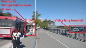
Choose the Londonviadukten stop for SL buses to the temporary terminal at Stadsgården (map, bus route map).
Or choose buses to/from the Folkungagatan stop to T Slussen (map, bus route map).
Tickets via card (e.g., Mastercard) or SL app.
Cash only in convenience stores like 7-Eleven and Pressbyrån.
Ticket is valid for 75 minutes across all SL trains, buses, and boats.
24-hour ticket (SEK 180 in 2025) also available online.
Viking Line buses: Timed with ferry arrivals/departures at Vikingterminalen. To/from Cityterminalen near Stockholm Central Station. Timetable.
- Sightseeing buses: Red and green hop on/hop off buses, stop at Vikingterminalen. Operated by Strömma Kanal.
SL bus Viking Terminal – SL temporary Stadsgården Terminal
- Choose the Londonviadukten stop for SL buses going to the temporary terminal at Stadsgården map, karta, <photo> busslinjekarta. bus line map.
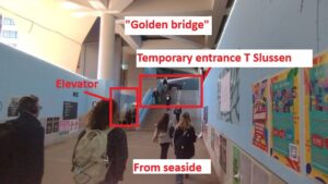
- After getting off at the Stadsgården Terminal, walk towards the ”golden bridge.” Just before it, turn right to the walkway leading to the city and the quay for the Djurgården ferry.
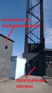
- Alternatively, turn left through a temporary walkway and stairs leading up to T-Station Slussen. <photo>
- Exit at Katarina Elevator. <photo>
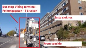
SL bus via Folkungagatan to T Slussen
- Go to the stop Ersta Hospital Folkungagatan <photo>. To/from the Folkungagatan stop to T Slussen: map, bus line map.
- Take the bus to the stop near T Slussen <photo>
Ferries
- M/S Emelie: A private passenger ferry between Hammarby Sjöstad and Stockholm City. Map.
Stops: Masthamnen/Vikingterminalen, Djurgården, and Nybroplan (T Östermalmstorg/T Kungsträdgården). Timetable. - SL ferries: Near T Slussen. Departure point at Räntmästartrappan in Gamla Stan, with routes including Djurgården. Timetable, Google Streetview.
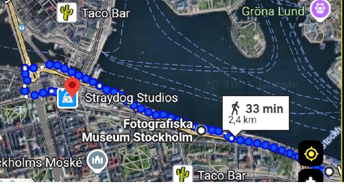
Easiest Walk: Along Stadsgårdskajen
Start at Vikingterminalen/Stadsgårdsterminalen (address: Stadsgården, 116 45 Stockholm).
Keep right and follow signs toward Slussen and Stadsgårdskajen. Google Streetview.
Follow the pedestrian path along the water (Stadsgårdskajen) westward to Slussen. Clearly marked and used by both pedestrians and cyclists.
After a couple of kilometers, you’ll reach Södermalmstorg, right at Slussen.
At Södermalmstorg, take the stairs up to the square (note: construction may affect walkways; follow signs).
The temporary entrance to the subway (Slussen, red and green lines) is located at the square. Google Streetview.
Fotografiska Museum is halfway between Vikingterminalen and Slussen.
SL bus lines to Nacka and Värmdö stop at Stadsgårdsterminalen between Fotografiska and Slussen. Google Streetview.
Learn about the city at Stockholm City Museum, located at Södermalmstorg near T Slussen.
From the Södermalmstorg exit: why not detour to the ferry terminal at Räntmästartrappan in Gamla Stan, with ferries to Djurgården and Strömkajen in the city. Google Streetview.
Fastest Walk: To/From T Medborgarplatsen or T Slussen
Google Map to T Medborgarplatsen | Google Map to T Slussen
- Up to Londonviadukten or Folkungagatan
Exit the terminal and turn left toward Londonviadukten, about 300 meters away (4 minutes walk).
Follow signs to Londonviadukten/Folkungagatan. Now you’re at the height of Södermalm.
Alternative: Walk along Åsögatan to Götgatan. Spot celebrities in trendy SoFo. Map. - Follow Folkungagatan westward
Turn left onto Folkungagatan and continue west through SoFo, known for cafés, restaurants, and shops.
Continue toward Götgatan.
3A. To T Medborgarplatsen
At the Folkungagatan/Götgatan intersection, turn left (south) onto Götgatan.
Walk about 500 meters to reach Medborgarplatsen, where the green subway line has a large entrance.
Total walk: ~1.5 km, 20–25 minutes.
3B. Alternative: To T Slussen
At the same intersection, turn right (north) onto Götgatan.
Walk about 400 meters to reach Slussen, served by both the red and green lines.
Total walk: ~1.2 km, 15–20 minutes.
Scenic Walk: Vikingterminalen – Mosebacke and Katarinahissen
This route is a bit longer than the direct waterfront path but offers much more scenery and cultural experiences.
Estimated walk: 20–30 minutes at a relaxed pace.
Follow signs for Mosebacke and Katarinahissen, and consider a break at the Mosebacke terrace before continuing to Slussen and the subway.
Route map via Katarinahissen
Söder’s heights: Fjällgatan, Mosebacke.
Read more: Walk Slussen – Mosebacke – Katarina Church. A lesson in the history of poverty.
- Start at Vikingterminalen (Stadsgårdsterminalen), Stadsgården 116 45 Stockholm.
- Walk toward Londonviadukten (about 300 meters/4 minutes). Follow signs to Londonviadukten/Folkungagatan.
- Take Londonviadukten up to Södermalm. Near Ersta Hospital and Fjällgatan.
- Turn right onto Fjällgatan – one of the best panoramic views in Stockholm toward Djurgården and Gamla Stan.
Pass cafés, viewing points, and the house of author Per Anders Fogelström. - Continue to Mosebacke.
When Fjällgatan ends, follow the path/stairs down to Katarinavägen.
Turn left, then follow signs to Mosebacke square.
Take stairs or path up to Mosebacke Square. Enjoy coffee at Mosebacke Terrace.
Visit Södra Teatern, one of Stockholm’s oldest and most legendary cultural venues.
Take the Katarina Elevator (if open) – great view! Elevator also available via Gondolen restaurant.
Or walk down Götgatan to the Slussen subway entrance. Google Streetview.
Experience the atmosphere of Stieg Larsson’s Millennium books.
Why not buy your SL ticket at 7-Eleven, Götgatan 25 – where Lisbeth Salander in the novels bought Billy’s pizzas.
Would you like this as a downloadable PDF or web-friendly format?
4o
Gillar du den här personligheten?
Sök
Resonera
Djup research
Skapa bild