Along Prästgatan where the wall was, easy to defend at the top at the brinktops. Route:
Get deeper.
- Along Prästgatan where the wall was, easy to defend at the top at the brinkkrönen. Route:
- Travel tips
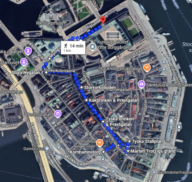
- Start Korhamnstorg
- Stop 1. Mårten Trotzig’s alley. Narrow and x stairs up the bank.
- Stop 2. German stables where Prästgatan meets Österlånggatam. First monks, then stables.
- Stop 3. German Brinken with the German Church. A Hanseatic city where German is in the walls.
- Stop 4. Kåkbrinken meets Prästgatan – and where Germans met Swedes
- Stop 5. Storkyrkobrinken. Where Prästgatan becomes a dead-end street, called Helevetesgränd.
- Stop 8. Murder-tainted Stora Nygatan
- Stop 9. Royal Palace Museum Tre Kronor at Lejonbacken 1
- Best way to travel from Lejonbacken
Travel tips
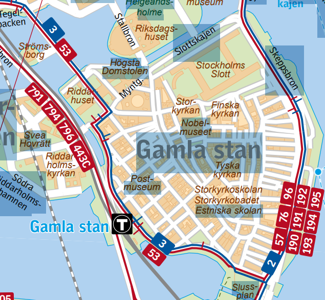
Take the metro’s green (13, 14, 17, 18, 19) or red line to the Gamla Stan station. From there it is about a 1-minute walk to Järntorget. You can also get off at Slussen, which is about the same distance (about a 6-minute walk). The nearest bus stops to Järntorget are Kornhamnstorg and Mälartorget – several buses, including no. 2, 3, 4, 53, pass here.
Start Korhamnstorg
The square retains its historic appearance with several preserved older buildings from the 17th–19th centuries, the hub for the Old Town’s public transport and restaurants. < Wikipedia > < streetview > < photo > < fotto > < Wikipedia > < streetview > < map > < info >
The Middle Ages. Originally, the harbor was where today’s Järntorget is located, and grain (mainly barley) was loaded here from Mälar farmers to the city during the Middle Ages. The place was the heart of the city and was called Stadsholmen. The Deucalion quarter , the Cerberus and Typhon quarter .
19th century. Here the mob attacked Axel von Fersen’s carriage shortly before the murder.
Stop 1. Mårten Trotzig’s alley. Narrow and x stairs up the bank.
The narrowest alley in the Old Town, at least 90 cm wide. The name is after the German merchant and burgher, Mårten Trotzig, who immigrated to Sweden in 1581 and bought properties on the alley in the Trivia quarter in 1597, 1599 and 1600. < Wikipedia > < streetview > < map > < photo >
Stop 2. German stables where Prästgatan meets Österlån ggatam . First monks, then stables .
< Wikipedia > < streetview > < map > < photo >
- The Middle Ages (14th–15th centuries). The land was used for outbuildings and simpler farms, often linked to nearby merchant farms. Prästgatan was a back street, and the site probably functioned as a farm or stable environment even then.
- 16th century. After the Reformation, ownership in the Old Town changed. Several church plots came under the crown or private hands. The area around Tyska stallplan began to be associated with households and stables linked to the Tyska house and later to the Tyska church (St. Gertrud) , which grew in importance for Stockholm’s German-speaking citizens.
- 17th century . The name “Tyska stallplan” is established: the site was used for the German congregation’s stables and outbuildings , often adjacent to the church. Prästgatan here was lined with simpler buildings, but the proximity to the church and the large German merchant estates gave the area a special character. During the Great Power era, the German bourgeoisie became a central part of Stockholm’s trade and influence, and the stableplan was a practical part of this everyday life.
- 18th century. After the castle fire in 1697, the area around the castle was rebuilt, but Tyska stallplan retained its function as a practical area for the needs of the congregation. The stretch of Prästgatan remained low-key, but priests, schoolboys and parishioners passed here to and from the Tyska church.
- 19th century. Stables and outbuildings lost their importance when horse farming decreased in the inner city. The area became more backyard-like , with simpler housing and small crafts. Prästgatan by the stables was long associated with a quiet, almost forgotten part of the Old Town, in contrast to the livelier main streets. The artist Karl Larsson lived as a child at Prästgatan 78.
- 20th century. The Old Town was under threat of demolition for a long time, but Tyska stableplan was preserved as a remnant of the old functional environments. In the 1950s–70s, the houses around Prästgatan were restored, and the stableplan became a picturesque place rather than a useful farm.
- 2000s. The place is a stark contrast to the hustle and bustle of Stortorget or Västerlånggatan – one of those places in the Old Town that preserves the feeling of having stepped aside into another time.
The Venus neighborhood
The Venus neighborhood is framed by Svartmangatan (north), Södra Benickebrinken (east), Tyska stallplan (west) and Prästgatan (south). < Wikipedia > < streetview > < photo >
- 14th century. In 1336 the Dominican monastery (Svartbrödrakloster) was founded here, on land donated by King Magnus Eriksson. Parts of today’s Venus quarter were within the monastery area. Wkipedia
- 16th century. The Reformation: the monastery was dissolved in 1528 and practically demolished during the 1540s ; in 1547 the demolition was noted in the city’s book of plans and building materials were reused in the city. app.raa.se
- 17th century. In the monastery area, Admiral Carl Carlsson Gyllenhielm had a private palace built in the 1620s ; remains of the monastery were built into the house. Most of the neighborhood names in the Old Town (including “Venus”) were added in the latter part of the 17th century , often after ancient gods. d
- 19th century. In 1864 the entire block was built with a new residential building. In 1876 a complete reconstruction and extension took place according to drawings by architect Carl Nestor Söderberg (preserved drawings exist). kipedia
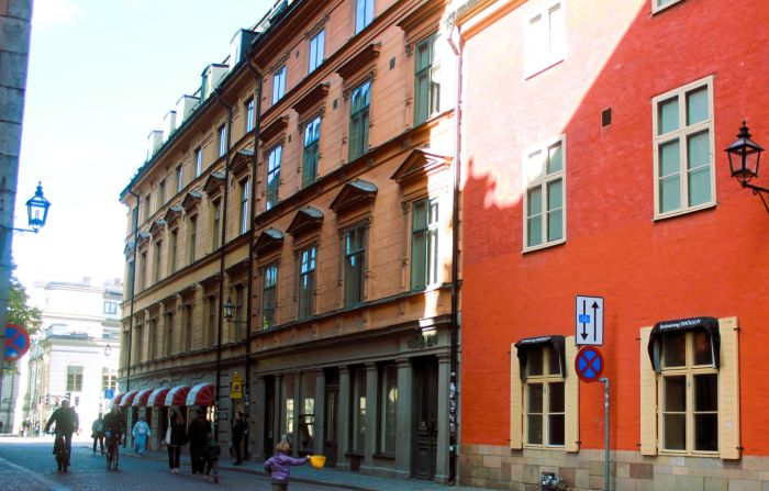
Stop 3. German Brinken with the German Church. A Hanseatic city where German is in the walls.
< Wikipedia > < streetview > < map > < photo >
- 14th century. The area began to be built in connection with Stockholm’s growth as a trading city. The German Church (St. Gertrud), which is located next to the German Brinken, had its first predecessor during this century through the German merchant congregation. The Brinken (the slope) was an important passage between and Skeppsbron .
- 15th century. The German congregation became a strong force in the city’s trade and politics. The church grew into a more monumental building, which influenced the streetscape around the German Brink. The Brink was used both as a transport route and as a social meeting place near the church.
- 16th century. Gustav Vasa and his sons strengthened the power of the crown, which affected the influence of the German merchants. The houses along the German Brink began to take on a more stone character instead of wood. The area around the church became one of the most prosperous parts of the Old Town.
- 17th century. Stockholm expanded greatly, and the German congregation was central to trade and culture. The church was built in a magnificent Baroque style with a tower (end of the 17th century). The street was lined with stately townhouses belonging to merchants. The German fringe became part of the official, representative Stockholm.
- 18th century. The area was characterized by the life of the bourgeoisie and Baroque/Rococo architecture. Many houses had richly decorated gates and stairwells. The German Church continued to be a central meeting place for Germans in the city. The street was a link between Skeppsbron (the city’s economic engine) and the central square.
- 19th century. During the period of industrialization, other groups began to move in, and the importance of the parish gradually declined. The German quarter lost some of its exclusive character. The houses were modernized but largely preserved older features. The street became part of the romanticized image of the Old Town, especially towards the end of the century.
- 20th century. The Old Town fell into disrepair during the first half of the century and many houses on Tyska Brinken were threatened with demolition. In the 1930s, the preservation movement grew, and Tyska Brinken was considered one of the most culturally and historically valuable streets. Restorations were carried out from the 1940s onwards. The street once again became a representative part of the Old Town and popular with tourists.
- 2000s. Tyska Brinken is today one of the central cultural and historical streets in the Old Town. The area is dominated by the German Church, craft shops and tourist streets. The buildings are protected and are used for both housing, offices and cultural purposes. The street still serves as a symbol of the multicultural character of Stockholm already during the Middle Ages.
German Church
It is easy for tourists to find the church, as the spire is visible over large parts of the older part of the city and marks one of Stockholm’s most historic environments. It has a tall copper-clad spire (96 meters), which is the highest point in the Old Town. < info > < Wikipedia > < streetview > < photo >
- The facade itself is built of dark red brick, divided by buttresses with elements of gray sandstone. The facade is also decorated with Gothic pointed-arched windows on the south side and round-arched windows on the north side. The tower is flanked by four tower clocks and is decorated with a gilded spire.
- Main entrance: The main entrance to the church is the south portal, which is richly decorated with sandstone and sculptures, including Jesus and Moses as well as symbols of Love, Hope and Faith. These sculptures were created by Jost Henne in the 1640s.
- Surroundings: The church is surrounded by a decorative cast iron fence with tall natural stone gate posts. Around the church are grassy areas with natural stone walkways and neat, pruned lime trees. The German Church’s majestic tower and detailed entrance make it a classic spot for photography and sightseeing when visiting the Old Town.
Stop 4. Kåkbrinken meets Prästgatan – and where Germans met Swedes
Kåkbrinken is one of the oldest streets in the Old Town, and several important events and stages in Stockholm’s history are linked to it. < Wikipedia > < streetview > < map > < photo >
- 11th century
At the corner of Prästgatan/Kåkbrinken sits the runestone U 53, built into the wall, erected by Torsten and Frögunn in memory of their son. Next to it stands a cannon barrel that was later placed there as a corner guard. - The Middle Ages. Kåkbrinken was a main road as early as the 13th–14th centuries and connected Stortorget with Söderport . The name “Kåkbrinken” is believed to come from the fact that the pillory (“kåken”) stood here, where criminals were publicly punished.
- 14th century. At Kåkbrinken was one of the oldest city gates in Stockholm – through it the road went south towards Södermalm. The street marks the border between the German and Swedish quarters in the Old Town (German merchants dominated north of Kåkbrinken, Swedes south of it).
- 15th century. The evidence for the name is from 1477, when a farm is mentioned, located nidhan fore kaakbrinken . In the Tänkeboken from 1496 a more detailed description of the alley is given; then the alley that runs west of the main square from the kaakin called Kakbringkin . The oldest information about the kåken on Stortorget, which gave the alley its name, is found in the story of the so-called Käpplinge murders from the first half of the 15th century. There it is mentioned that some men came from the castle and stayed with the kakin . Read more about the murders: < The years as the city of pirates >
- 1520s. According to some sources, prisoners sentenced to death were taken via Kåkbrinken to Stortorget, where the executions took place.
- 17th century. The houses along the street began to get their current stone facades in the Baroque style.
- 18th–19th centuries. The area around Kåkbrinken was largely populated by craftsmen and ordinary citizens, which leaves traces in the appearance of the houses and small workshops. The shame pole remained for a long time – the last documented use was in 1778.
- 20th century, In connection with urban planning and threats of demolition in the Old Town in the 1930s–40s, Kåkbrinken was part of the discussions that led to the preservation of the Old Town as a cultural environment. Read about S Lundgren’s Ved och kol at Prästgatan 15.
Stop 5. Storkyrkobrinken. Where Prästgatan becomes a dead-end street, called Helevetesgränd.
< Wikipedia > < streetview > < map > >photo> < photo >
- 13th–14th centuries (Middle Ages). Storkyrkobrinken was the main road up to the city church. Here there was a city gate called Sancte Nicolauese Port (paved in 1422), and just to the west St. Laurentii Gränd (1436). . Already in the late Middle Ages there were blacksmiths, tailors, shoemakers and chamois makers here. A schoolhouse was built in 1431.
- 15th century. The small stretch north of Storkyrkobrinken was called Helvetiegränden . The surrounding area is referred to as “Hell” in 15th century sources, possibly because the executioner lived there.
- 16th century. Backen appears in sources such as Kyrkobrinken (1596) and S. Niclaes Brinck (1597). Prästgatan is mentioned in 1586 as Prästegathen , after the priest’s residences at Storkyrkan.
- 17th century (Great Power period).n Storkyrkobrinken was widened during the 17th century, which meant that older house basements ended up below street level. Names such as Slottsgatan (1637), Riddargatan and Riddarhusgatan were tried, and people began to distinguish between Svenska Kyrkobrinken and Tyska Brinken . Postmaster General Johan von Beijer had the Beijerska huset (Storkyrkobrinken 4) < Wikipedia > built during the 1640s–60s. < photo > At the same time, the cannon barrel was walled in at the runestone to protect the corner. <photo> Axel Oxenstierna’s Palace , or Oxenstiernska palatset , is a wing building to an originally planned palace at Storkyrkobrinken 2 and Högvaktterrassen in Gamla stan , Stockholm , designed by architect Jean de la Vallée for Chancellor Axel Oxenstierna and construction began in 1653 and the building was completed in the 1650s. < photo >
- 18th century. The street names were stabilized, and in 1771 the name Storkyrkobrinken was established . The southern part of Prästgatan was called Tyska Prästgatan (priests at the German Church) and the northern part Svenska Prästgatan (priests at the Storkyrkan).
- 19th century. The Paris uprising of March 1848 spread to Stockholm, with young men fighting and throwing stones in Storlyrkogänd. The cavalry charged the crowd with pointed weapons. [ People were beaten, injured and killed. < Wikipedia > < map > < info >
- 1900s. Storkyrkobrinken was Stockholm’s book street in the 18th and 19th centuries. Here, publishers and booksellers were located side by side.
Stop 8. Murder-tainted Stora Nygatan
The north end of Prästgatan (Helvetesgränd) is blocked. Therefore, we will walk from Storkyrkobrinken to Stora Nygatan 1.
< Wikipedia > < streetview > < map >
19th century. The lynching of Axel von Fersen, known as the Fersen Murder, took place on 20 June 1810 in the middle of Stockholm, more precisely at Västerlånggatan and Riddarhustorget. Axel von Fersen was the Marshal of Sweden and a high-ranking nobleman, but after the sudden death of Crown Prince Karl August, false rumors spread that von Fersen had been involved in a planned murder. Public discontent and political intrigue caused the atmosphere in Stockholm to become hostile on the same day as the Crown Prince’s funeral procession.
During the procession, von Fersen’s carriage was attacked by the crowd; the windows were smashed and he was first beaten at Stora Nygatan 1. He tried to seek shelter at the intersection with Storkyrkobrinken , but was dragged out by the people. The beating continued at Riddarhustorget . < map > Although the Svea Life Guards were on site, the soldiers did not intervene, and Axel von Fersen was beaten and kicked to death by the crowd. No individual was convicted of the murder, but it is said that his chest was eventually broken when someone jumped on him.
“Axel von Fersen + Marie Antoinette. Really? Wander with the Count in Stockholm, from childhood to the lynching ”
18th century. Magdalena Rudenskiöld was hanged on Riddarhusplan a few steps from the place where Axel v Fersen was later lynched to death. Magdalena’s death sentence in 1794 was commuted to Långhplmen’s spinning house. Duke Karl shared his mistress Magdalena Rudenschöld with General Gustaf Mauritz Armfelt , once Gustav III’s confidant. To win back Armfeldt’s love , Magdalena was his messenger to the Russians when they sought support for a coup d’état. Rudenskiöld’s spies discovered both this and her 1,000 love letters to Armfeldt (who had taken refuge in Hovdam security in Russia).
Stop 9. Royal Palace Museum Tre Kronor at Lejonbacken 1
Museum Tre Kronor is a museum about the old castle Tre Kronor. Preserves the basement parts of the old castle, the oldest rooms are from the 14th century.
< Wikipedia > < streetview > < map > > photo >
The museum is located in the cellar vaults under the northern castle wing, with an entrance under Lejonbacken through the thick defensive wall from the 13th century. The museum contains models that show the appearance of Stockholm Castle from the defensive fortress to the castle fire in 1697. Objects are displayed that were saved from the fire, such as the lower part of marble columns. From the 1570s in Johan III’s castle church which was located in the northern wing.
The visitor will see:
- Exhibitions about how the Vikings set up pile dams at the site as early as the end of the 9th century.
- Historical objects, documents and models that show the castle’s development from a defensive fortress to the palace that became Tre Kronor.
- Reconstructed parts of walls from the 14th century that visitors walk through on their way into the museum.
- A model of the Tre Kronor Castle before the fire in 1697.
Best way to travel from Lejonbacken
Walk
Lejonbacken is only about 440 meters from Stockholm Central , which takes about 5 minutes on foot . Perfect if you are going towards the City or the commuter train station.
Subway (T-bana)
- Old Town – about 5 minutes walk.
- Kungsträdgården metro station – about 7 minutes walk.
- From there you can reach Stockholm’s metro lines (blue, red, green).
Bus
Lines such as 2, 3, 4, 57, 96, 191-195 are within walking distance.
Ferry
- Strömkajen is only about 6 minutes away on foot, where ferry lines depart.
- The Djurgården ferry at Skeppsbron
/ By Ingemar Lindmark